Precision farming technologies allow the farmer to quickly and easily collect information about the condition of the fields on which the crop is growing. Although, if desired, you can inspect the fallow fields. Satellite observation and UAV usage are especially simplified today. But the current situation is such that some models are in greater demand than others, so you can use this attribute as a quality criterion.
Drones used in agriculture are more expensive than amateur ones, which is associated with high demands on the quality of images. The purpose of the application may be different, which affects the equipment of the device before departure. Usually, when examining the fields, the farmer is primarily interested in whether the plants receive enough moisture, fertilizers, whether there are any damage by various pests. During applicating of the herbicides accuracy and timing are important.
The process of obtaining information should be as simple as possible for a person with ordinary training.
Typically, two groups of people are interested in agricultural drones:
Also, you need to understand the radical difference between a UAV with a rotor (s) from a model with a fixed wing. The quadcopter moves more slowly, but can hang if necessary. It is needed to obtain high-quality images, but the processing area is not as large as that of “aircraft-like” UAVs. A fixed-wing drone cannot hover like a quadrocopter does, but it processes a 10 times larger area in the same unit of time. Although the image quality when shooting at high speed can suffer. Therefore, fixed-wing models are more suitable for express inspection of a large area.
Information that can be obtained during the inspection of the territory:
Design properties of agricultural drones that need to be considered:
Immediately upon purchase, or rather, before it, find out if the price of the drone includes the service for processing photos received. After flying around even a small field, you will have a large number of images that need to be processed and get from them a two-dimensional orthophotomap or a three-dimensional model of the field. For a regular home computer, such work can be an overwhelming task, and the cost of renting cloud services can range from 350 to 9,000 dollars a month. Therefore, a subscription for several months of using such a service is a very weighty argument in favor of one or another dealer.
Fixed wing UAV
UAV multicopter
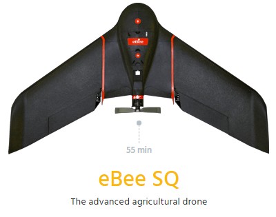
Weight – 1,1 kg.
Max. speed – 40-110 km/h.
Flight time – 55 minutes.
The maximum range is up to 8 km.
Hand launch (without catapult) - possible.
Sensors - Sequoia+ multispectral camera is preinstalled.
The data obtained is the image in the visible spectrum and the display of the NDVI index on the two-dimensional orthophotomap of the field with reference to GPS coordinates.
Shooting Resolution:
The shooting process is automated, the light sensor allows you to take images with calibrated brightness values under changing lighting conditions.
This model is perfect for exploring large areas and can be used by the farmer after minimal preparation, since there is no need to control the flight itself - it happens automatically.
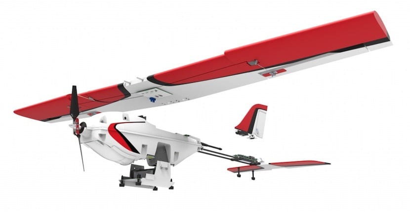
Weight – 3,5 kg.
Max. speed – 80 km/h.
Flight time – 40 minutes.
The maximum range is 2 km.
Hand launch (without catapult) - possible.
Sensors - configuration options available. The data received will depend on the installed camera.
The data received will depend on the installed camera.
The shooting process is automated - two modes: manual and automatic using the built-in GPS sensor.
This model is distinguished by a robust hull, which makes it easy to carry multiple hard landings in agriculture, geological exploration, and inspection of industrial facilities.
Suitable for reconnaissance and the introduction of plant protection systems, can be used by personnel after training to manage such a device.
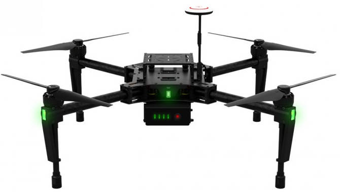
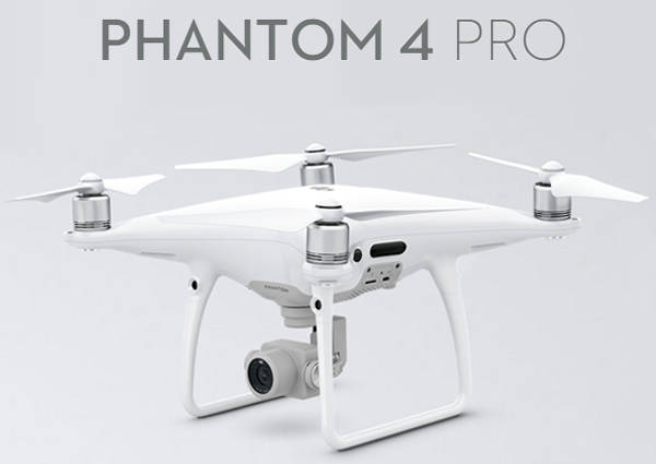
This solution from the leader in the UAV market - DJI, compares favorably with the flexibility of customization. Various sensors can be installed on this module: ultrasonic, cameras, telemetry and navigation units, stabilizers. There is a system to avoid collisions with various objects during the flight.
Weight – excluding additional modules - 2,4 kg.
Max. speed – 60 km/h.
Flight time and maximum range - depends on the number of batteries.
Hand launch (without catapult) - take-off and landing from the soil without human intervention.
Sensors - the platform provides a choice for installing various sensors.
The data received will depend on the installed camera.
The flight and shooting process are automated, plus there is a function of automatic return home.
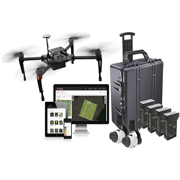
As the name implies, this is a set of equipment that can be picked up independently, but in this case the package is more profitable. The carrier of all this equipment is the DJI Matrice 100 modular drone, described above. Suitable for solving many problems, it was originally created for using in various purposes by untrained personnel. That is, the farmer can install new elements or replace them independently.
Weight – Unequipped DJI Matrice 100 - 2,4 kg
Max. speed – 60 km/h.
Flight time – 40 minutes.
The maximum range is about 20 km.
Starting from the ground is possible.
Sensors included in the DJI Smarter Farming Package - 1 sensor of the visible spectrum, 1 multispectral.
The data obtained is the picture in the visible spectrum and the NDVI index on the two-dimensional orthophotomap of the field with reference to GPS coordinates, assessment of weather damage, assessment of weeds, damage from pests, services provided as part of the annual subscription to DataMapper Standard. Simplifies the work of farmer by the applications for smartphones and personal computers.
The shooting process is automated, the process of flying around too, just specify the territory for flying around and the trajectory will be built automatically.
This is a specialized modification of the platform drone intended for farmers. Equipment designed to evaluate the NDVI index and RGB is installed on the basic package.
Weight – 1,4 kg.
Max. speed – 71 km/h.
Flight time – 30 minutes.
The maximum range is 30 km.
Hand launch (without catapult) - possible.
Sensors – GPS, GLONASS.
Shooting resolution - photo camera: 5472×3648, video: 4096×2160, NDVI index.
The flight and survey processes are automated.
This modification includes Sentera's AgVault imaging software.
This solution is complex, includes UAV itself, sensors of the visible spectrum and multispectral.
Comes complete with 4 batteries, which allows you to explore 100 hectares of territory.
Max. speed – 60 km/h.
Flight time - one battery of 24 hectares or 20 minutes.
Starting from the ground and landing are automatic.
Sensors - the developer company claims that this UAV provides an image in the visible spectrum and displays the NDVI index on a two-dimensional orthophotomap of a field with reference to GPS coordinates.
The data obtained can be processed by the software that is included in the package.
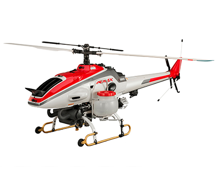
In fact, this is a miniature helicopter with a two-cylinder gasoline engine. Its maximum carrying capacity is 28 kg, useful - 16 kg, the diameter of the main blades is 3.1 m, the body length is 2.75 m.
Max. speed – 100 km/h.
An original feature of this model is the presence of two separate containers (max. 8 kg each) and two sets of nozzles, which allows two different working fluids to be introduced in one flight when they are chemically incompatible (for example, pesticides and fertilizers). Variation of the norm of pouring is 1.3-2 l/min.
During the development of this UAV, emphasis was placed on simplification and cheapening of operations for the introduction of plant protection systems. Yamaha RMAX is smaller than a conventional helicopter and therefore more economical. At the same time, it can make plant protection measures where manned aircraft cannot cope - next to trees, power lines. To work with such equipment will require specially trained personnel.