 The development of resource-saving technologies in agriculture will allow the industry to enter a qualitatively new level of production that will allow (with certain changes in the policy of the state supporting agriculture) agricultural producers to compete with foreign enterprises.
One of the basic elements of resource-saving technologies in agriculture is "precise farming" (or as it is sometimes called "precision agriculture" - precision agriculture). Precise farming is the management of the productivity of crops, taking into account the in-field variability of the plant habitat. Relatively speaking, this is the optimal control for each square meter of the field. The purpose of such a management is to obtain maximum profit under the condition of optimizing agricultural production, saving economic and natural resources. At the same time, real opportunities are opened for the production of quality products and preservation of the environment.
Such an approach, as international experience shows, provides a much greater economic effect and, most importantly, allows to increase the reproduction of soil fertility and the level of ecological purity of agricultural products.
Currently, rising prices for seeds, mineral fertilizers, plant protection products, machinery and other means of production in agriculture lead to the need to increase the efficiency of their use.
The leaders and specialists of agriculture are faced with the task of increasing the level of management as an important factor for achieving efficient management. The task poses a new direction called precision (precision) farming, which is now becoming increasingly common in many
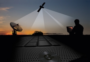
Precise farming – is an integrated high-tech agricultural management system that includes global positioning (GPS) technologies, geographic information systems (GIS), Yield Monitor Technologies, variable rate technology and remote sensing technology.
The essence of accurate farming is that field processing is performed depending on the actual needs of the crops grown in the given place. These needs are determined with the help of modern information technologies, including space imagery. In this case, the processing means are differentiated within different parts of the field, giving the maximum effect with minimal damage to the environment and reducing the total consumption of the substances used. The most important issue solved recently in European countries was finding the optimal level of fertilizer and chemicals in crop production, as well as determining the dosage of their application, excluding the negative impact on soil, plants and the environment.
The accumulation of processing statistics (where and how much each substance was contributed) and the results obtained (yield) makes it possible to apply different types of analysis in order to subsequently adjust the applied doses to obtain the maximum return on each ruble invested in processing.
1. A system for collecting spatial information (remote sensing, ground-based analytical methods);
2. System of spatial control of operations: GPS (satellite navigation devices) and sensor sensors.
In the near-Earth space, a network of artificial Earth satellites is deployed, which uniformly “cover” the entire earth's surface. The orbits of the satellite are determined with very high accuracy, and therefore the coordinates of each satellite are known at any time. The radio transmitters of satellites continuously emit signals in the direction of the Earth. These signals are received by a GPS receiver located at some point on the earth's surface, the coordinates of which must be determined.
To determine the location of the point, you need to know the three coordinates (the flat coordinates X, Y and the height H), therefore, distances to three different satellites should be measured in the receiver). With this method of radio navigation (it is called unquestionable), a precise determination of the signal propagation time is possible only if there is synchronization of the satellite and receiver time scales.
In this connection, the satellite and receiver equipment includes reference clocks (frequency standards), the accuracy of which is exceptionally high (long-term relative frequency stability is ensured at the level of 10-13 - 10-15 per day). The onboard hours of all satellites are synchronized and tied to the so-called “system time”.
The time reference of the GPS receiver is less precise so as not to increase its cost excessively. This standard should provide only a short-term frequency stability - during the measurement procedure.
In practice, there is always an error in time measurements due to the mismatch between the AIS and receiver time scales. For this reason, the receiver calculates a distorted distance value to the satellite or “pseudorange”. Measurements of the distances to all satellites with which the receiver is operating at the same time occurs simultaneously.
Therefore, for all measurements, the magnitude of the temporary discrepancy can be considered constant. From a mathematical point of view, this is equivalent to the fact that not only the coordinates X, Y and H are unknown, but also the correction of the clock of the receiver D t. For their determination it is necessary to perform pseudorange measurements of up to three, and up to four satellites.
As a result of processing these measurements, the coordinates (X, Y and H) and exact time are calculated in the receiver. If the receiver is mounted on a moving object and along with pseudo-ranges measures Doppler frequency shifts of radio signals, the speed of the object can also be calculated. Thus, to perform the necessary navigation definitions, it is necessary to ensure a constant visibility from it of at least five satellites. After the satellite constellation is fully deployed, from 5 to 12 satellites can be seen at any point of the Earth at any time. Modern GPS receivers have up to 12 channels, i.e. Can simultaneously receive signals from such a number of satellites. Excessive measurements (in excess of five) make it possible to improve the accuracy of the determination of coordinates and to ensure the continuity of the solution of the navigation problem.
Scientists and designers understood that the system of exact farming should be based on the latest achievements of electronics. However, the testing of the first experimental samples showed that complex and expensive electronic devices are not suitable for field conditions that are characterized by increased dustiness and humidity of the environment, require highly qualified maintenance and repair in the event of deficiency of spare parts. But very soon they were adapted to agriculture. Microprocessors, electronic, photoelectric, capacitive, electromagnetic, piezoelectric, electromechanical and other sensors, as well as electronic devices.
The first significant results in the use of electronic devices on agricultural machinery. Technicians have developed machines for plant protection. For example, the sprayer of Tecnoma Hydroelectron, which received a gold medal at the SIMA-1976 international exhibition in Paris, was equipped with an electronic regulator of solution supply in proportion Speed of movement of the unit. A similar machine was developed by the English company Agmet. Compared to the analogues used in the CIS countries, they maintain a constant solution consumption per unit time, and the rate of its application per 1 ha varies considerably with each gear change, engine speed and wheel slippage, which saves up to 20% of pesticides. And this is not only an economic, but also an environmental effect.
It was more difficult to solve the problems of exact seeding of grain cereal crops. Experimental samples of such seeders were shown at an international exhibition in Munich in 1982, and the serial machine with the electronic regulator of seeding by Blanchot appeared only after three years and was marked at the Paris exhibition SIMA-1985. Rider (Germany) went even further by creating a Saxonia drill that provides not only the seed spacing in the row, but also the depth of their embedding.
Significant successes in the electronization of agricultural crops. The equipment reached the company Amazone, Diadem, Rotina, Lely, etc. In centrifugal type machines, they achieved the independence of the dose of fertilization per 1 hectare Of the speed of the unit. In addition, the frequency of rotation of the scattering discs and the actual dose of fertilizers applied per hectare are constantly displayed on the monitor, and the last tractor driver can change from his workplace.
The use of electronic devices made it possible to significantly (up to ± 15%) reduce the uneven application of fertilizers.
In 1986, as a result of close cooperation between the companies — Manufacturers of tractors and agricultural machinery, it was found rational to install a multichannel microprocessor on a tractor, and use only standardized sensors on machines.
And the microprocessor not only controls and regulates the technological parameters, but also shows the actual operating speed of the unit, the amount of work performed, engine parameters and specific fuel consumption.
To unite efforts to develop and develop electronic systems in agricultural production in 1992, the EU countries adopted a plan providing for accelerated financing from the EU budget of promising areas of automation and computerization of agricultural products. Techniques. At present, Hungary, Czech Republic, Slovenia and Estonia have joined this work. And in creating qualitatively new, high-precision and high-performance machines, Western European countries have considerably bypassed the USA and Canada.
Thanks to the use of high-precision machinery in countries with developed agriculture, it was possible to raise the yield of grain crops to 90 c / ha and to obtain a substantial profit. At the same time, it was noted that the diversity of yields in the fields treated with this technique, although significantly reduced, but still preserved. Consequently, such agriculture does not yet meet the exact criteria. Agrochemical analysis of soil taken at sites with different yields showed that they differ significantly in nitrogen, phosphorus and potassium content, although mineral fertilizers were applied with high uniformity. The reason for this phenomenon is that plants feed on not only substances that are introduced into the soil during cultivation of a given crop, but also by those that accumulate in it. Therefore, fertilizers need to be introduced into the soil in different ways, depending on the number of basic nutrients previously accumulated in it.
However, the introduction of such technology using existing technical means is associated with great labor and financial costs. In this regard, in different countries, ways and means have been developed to simplify and reduce the cost of agrochemical soil analysis, including through the yield of grown crops in selected areas of the field. For this, for example, a combine harvester is equipped with an electronic device that determines the yield, coordinates it logically into the on-board computer and prints out the cartogram. But the yield map can serve only as a means of justifying the need for differentiated application of fertilizer or for determining abnormal zones and for taking soil samples for agrochemical analysis only in these zones. One of the cardinal solutions to this problem was proposed by the English company KRM — To estimate the content of nitrogen, phosphorus and potassium in the soil by photographing the fields in infrared rays onto a special film with the help of an airplane or satellite.
Even simpler agrochemical soil analysis created by the English company Challeng Agriculture optical device (gold medal at the Paris exhibition in 1994 ). The content of nitrogen, phosphorus, potassium and other elements in the soil is determined by comparative measurement at two points of reflected light of the selected band of the spectrum. It can process more than 30 parameters and store 50 values. Four years later, a similar device was developed by Chinese specialists based on transistors, converters, photo sensors and other electronic devices.
Another difficult problem — Binding of the results of agrochemical analysis to the coordinates of sampling and transfer of these data to the fertilizer application unit. A fairly well-known tool for determining the coordinates of the aggregate — Rotary device, the measuring element of which is the wheel of a tractor or a machine, and registering — Speed counter, the scale of which is graduated in meters. The deviation of indications on the length of a 1000 m run does not exceed ± 2 m.
Claas has developed a radio system that includes a computerized radio base station with a receiver located in the company's office (premises) and transceiving devices — On field assemblies. With this system, it is possible to find the coordinates of 200 units operating within a radius of up to 9 miles, with an accuracy of ± 10 m.
In the radio system of a similar purpose, Massey Ferguson uses special radios installed on the aggregates and a global satellite network (GPS). The system with an acceptable accuracy determines the geographical coordinates of the unit, but it is quite complex and expensive.
The first experimental sample of a two-disk centrifugal machine for the differential application of one type of mineral fertilizer was demonstrated in 1994 at the Smithfield Farm Tech exhibition by the British company KRM. The content of nutrients in the soil is determined by the method of infrared photography of the field from the satellite.
The earth with the construction of the field cartogram, and the coordinates of the unit — Using GPS. To directly change the dose of fertilizers applied, an electronic device Calibrator 2002 is used, which is functionally connected to the computer (on the diskette of which the field field map is recorded) and the GPS system. In 1995, Amazone company mastered the serial production of ZA-Max centrifugal machines with similar devices.
However, because of the high cost of electronic equipment (about 50% of the price of the machine), they are not widely used.
The pioneer in the development of precision farming is the United Kingdom, where on a farm in the county of Safolk for three years map yields, coordinate analysis of soil in abnormal zones, and fertilizers were introduced by another Amazone-M-Tronic machine. This provided an annual saving of 17.2 pounds sterling per hectare (compared with the introduction of constant doses throughout the field).
The technology has proven itself and is successfully used in the USA, Canada, Brazil and in Europe. In the US and Canada, navigation equipment is especially common, because In the production of wide-grabbing technology is used.
To date, all the world leaders in the production of agricultural machinery (CLAAS, John Deer, Case, etc.), complete their equipment with a GPS navigation system. In Russia, «the pioneer» in this direction became the company «Eurotechnique», since 2004 all agricultural machines produced in the plant can be upgraded with a GPS navigation system.
GPS – Equipment is in demand due to the fact that it provides cost savings. In Europe, for example, it is estimated that the economic effect of the application of GPS – Equipment reaches 50-60 euro per hectare.
In addition, users of this equipment get the opportunity to conduct field work at night, in fog, with increased dust.
Currently, comparing the produced Russian and foreign satellite navigation devices for work in agriculture, we can say that foreign devices have advantages over their own.
Navigation devices of Russian production are still very few. As an example, you can bring the navigation device «Agronavigator». It is quite multi-functional: it allows you to drive a tractor in parallel while spraying, applying mineral fertilizers, record and store information from an area of up to 10,000 hectares. However, the accuracy of this device is from 1.5-2 m, which is not permissible in agricultural work.
International experience includes many more similar devices: the famous John Deere company with the Green Star Parallel Tracking System, and the lesser known Mid-Tech Center-Line, Raven RGL 500, Cultiva ATC, Outback S, and others. However, the indisputable leader in this direction today is the company Trimble with the family of navigational instruments of the AgGPS series, which are widely used in precision agriculture in Europe, the USA, Canada, and now in Russia.
Thus, in recent years, the system of accurate farming has been massively integrated into the agriculture of many countries. As for Russia, only a small number of enterprises decide to use this system. This is due primarily to financial difficulties in implementing this system.
GPS-based positioning systems are already successfully used in some Russian agribusinesses, contributing to increased productivity and quality of agrotechnical operations and conservation of the ecological balance of the field. So, OJSC «Agrofirma «Bunyatino» Dmitrov district of the Moscow region successfully uses the parallel driving system Trimble, universal for all types of agricultural machines.
The system allows increasing the efficiency and accuracy of all agricultural operations: soil cultivation, sowing, spraying, fertilization and harvesting.
Accurate navigation minimizes gaps and overlaps in adjacent aisles, which ultimately results in savings in seed, fertilizer, chemicals and fuels. Since the system eliminates the need for signalers, the cost of additional staff is reduced. Agricultural operations are faster. It is important that the system makes it possible to work in conditions of poor visibility, including in the dark. Moreover, the system is a resource-saving technology: due to the reduction of overlapping strips, the overuse of fertilizers and plant protection products (PPP) is reduced to a minimum. Due to accurate navigation, it does not » The initial technological track: the system remembers the trajectory of motion and gives the mechanic the ability to accurately hit the same track when the field is re-machined.
The main advantage of using parallel driving systems when spraying – Reduction to a minimum of flaws, inevitably arising in this operation, especially if it is produced by wide-cutting technique and in conditions of poor visibility. For example: when treating with herbicides, such flaws can negatively affect the yield of not only untreated plots, but also the entire field. When driving in the usual way, the mechanizer, trying to avoid omissions, tries to pass adjacent rows with overlapping, which greatly aggravates the phytotoxicity of the preparations. In the final analysis, the overlap is, according to various estimates, from 5 to 15% of the area. The use of GPS navigation reduces the mutual overlap of the rows to 1-3%. At the 18 meter long sprayer bar at a distance of 45 cm from each other there are 40 spray nozzles. Focusing on the foam marker, pegs or signalers, the driver creates overlapping from 50 cm to 1.5 m, that is, on each pass 2-3 extra nozzles pour out a pesticide on the field, which significantly increases the hectare cost of processing the crop.
Currently used satellite navigation system allows to achieve processing accuracy of 15-30 cm from the pass to the pass.
The system consists of several components: the guidance pointer EZ-Guide 250/500 with a built-in satellite receiver, thruster EZ-Steer or navigation controller NavController II.
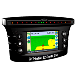 The Trimble EZ-Guide 250 positioning indicator is installed in the tractor cab and indicates to the driver the direction for precise driving along parallel rows during field work. It consists of an LED panel, a color 4-inch display and an integrated 12-channel GPS receiver. Bright LEDs show the driver, in which direction the tractor deviates from the ideal trajectory and the magnitude of the shift.
Using the Trimble EZ-Guide 500 system has an extended range of accuracy from pass to aisle (2.5-30 cm). This device contains a high-precision dual-frequency receiver GPS/DGPS/RTK and a 7-inch display. The receiver makes it possible to use, from year to year, the «old trajectory» and easily upgraded to a higher level. Using the thruster EZ-Steer eliminates flaws, increases the effective operation of agricultural machinery, due to the ability to work in the dark, in poor visibility conditions and significantly reduces the fatigue of machine operators. When the end of the rut is reached, the mechanic can only bring the car to a new line using the help of the guidance pointer and then connect the EZ-Steer, which transmits the force through the rubber roller to the steering wheel.
The built-in software of the Trimble EZ-Guide 250/500 guidance indicators allows you to map the fields - when traversing the field along the contour, determine the exact coordinates of the field boundaries and calculate its total area.
For the driver, working with the system is quite simple: the first pass, the machine operator performs manually. Specifies the width of the aggregate, specifies the start and end points of the movement. Then the system automatically marks the plane of the field in the indicator pointer by lines parallel to the specified one and with a width equal to the grasp width of the unit. Next, the driver needs to move along these trajectories. The system supports not only rectilinear, but also curvilinear and spiraling modes of motion. Practice shows that the mechanic learns the menu of the indicator pointer in about one to two hours. Another three hours are required for the mechanic to «fill his hand» and acquired the skills of straight-line driving with the use of the guidance pointer. The accuracy provided by parallel driving systems can be illustrated by the following table. It should be borne in mind that with increasing accuracy of the system, the area of its application increases.
The effect of using parallel driving is obvious and is confirmed by experience. So, for example, when the seeding complex was working, the butt spacing was set to 25 cm with a distance of 35 cm between the openers. When the unit was operating, the width of the butt joint was varied within 5 cm. Thus, the use of a high-precision guidance pointer with a thruster makes it possible to minimize overlaps and carry out sowing with the value of butt spacing equal to the inter-spacing distance. Overlapping decreased to 10%, and consequently, the overexpenditure of seed, fuel and mineral fertilizers was reduced. By increasing the replacement capacity by 20% and increasing the working time by 40% due to work at night, the time of field work is greatly reduced.
ЗАО «Agrofirma «Bunyatino» Dmitrov district of the Moscow region uses a parallel driving system for potato fields and fields with open ground vegetables from March 2010 to the present. An investment project was developed with the required economic justification. The essence of the project was to purchase and install the necessary equipment, which allows to significantly increase the accuracy of agrotechnical operations on tilled crops.
Financial resources required for the implementation of the project amounted to 3150 thousand rubles.
As for the payback period of the project, the project fully covers its costs in the first year of using the parallel driving system.